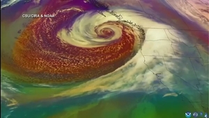
FRESNO COUNTY, Calif. (KMJ/KFSN) — A bomb cyclone is swirling over the Pacific Northwest and steering an atmospheric river event toward Central California.
The National Weather Service says Mariposa and other foothill communities could see the greatest risk for flooding starting Friday.
“The areas that we are looking at are contained to foothill communities for excessive rainfall. That is the main concern. The other areas of concern are burn scars, that includes the French Fire,” says Stephen McCoy, National Weather Service.
“This will be a very significant snowfall event. Our first one of the year. You can see that in the Tioga pass there’s 100% chance of one or more feet of snow,” says McCoy.
McCoy says higher elevations could get a foot of snow or more.
Terri Mejorado, Emergency Manager with the Fresno County Office of Emergency Management, says her team tours various local dams and vulnerable areas ahead of events like these to make sure they’re ready.
“From what I’m seeing and what I’m hearing while we may get a decent amount of rain out of this, nothing to be of concern. It’s going to come out over several days, it would be an issue if we’re having all of that within a couple of hours,” says Mejorado.
PG&E is also mobilizing crews and prepping gear.
Teams are already responding to the about 11,000 outages up in Northern California.
“We do expect some of the severity will dissipate as it moves south. That’s what our meteorologist are seeing right now, but we do have crews essentially on standby ready to respond and restore customers as safely as possible,” says Jeff Smith, PG&E Spokesperson.
Information on updated alerts, such as road closures and where you can find sandbag locations, can be found here.


