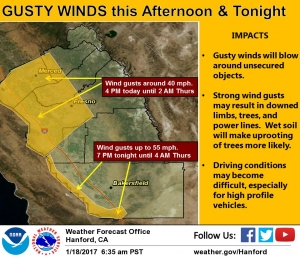
FRESNO (KMJ) — The bands of precipitation forecast for the Central Valley have prompted both a Winter Storm Warning in the Sierra Nevada above 5000 feet, and a Wind Advisory in the lower elevations.
Both are in effect from Wednesday evening until Thursday morning. The wet weather associated has also renewed flooding concerns in the Central Valley.

“Where there’s snow rather than rain, it won’t be an impact, but the parts down in the foothills where it is actually raining it will be an influence because the streams and rivers are higher than they had been,” explains National Weather Service forecaster Jim Bagnall.
“So it won’t take as much to cause flooding.
“It will still have to be watched as it progresses through, but not the big threat as the previous systems were.”
Snow levels in the higher elevations, could be as much as two feet after the system passes through.
Hear the report from KMJ’s Dominic McAndrew as it aired:


